professional-work
Location-based social platform — connecting the app and map WebView
I worked on map features and the WebView in a photo and place discovery app. I separated state from commands to keep the app and map on the same place, and refined map updates and bottom-sheet interactions.
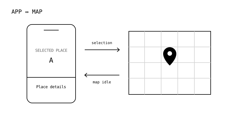
Keeping the same place selected across the map and app
The location-based social platform is a mobile app for exploring photos, places and feeds. Within the team, I worked on map-focused app features, the Google Maps WebView and the bridge connecting them.
To the user, this was one map. Internally, the WebView rendered it while the React Native app fetched data and handled navigation. Highlighting a search result or opening details from a marker required both surfaces to agree on the selected place.
I separated state that needed to persist from commands that should run once. Marker data and selection remained shared state; moving the camera to a place became a separate command. I defined the contract in TypeScript and aligned the policies for manual selection and automatic highlighting.
Making the interaction work as well as the data
Rather than reporting every camera change during movement, I sent updates to the app when the map became idle. Supercluster and viewport bounds determined which markers to display, while comparisons and memoization controlled rendering.
In the app, I connected cached locations with OS location queries. I also adjusted the place-detail bottom sheet’s touch areas and dragging behavior. Agreement between data was only part of the task: the map and sheet also needed to respond to touch without obstructing each other.
The resulting implementation connects search, camera movement, marker selection and place details in both directions. The app-side map features and the WebView are best understood as two sides of the same interaction.
What should remain when the surface changes?
Search results also needed to retain their context. I included coordinates in cache keys, adjusted precision and separated requests by keyword/location combinations, guarding queries when the current location was unavailable. Shared response schemas distinguished empty and nullable responses so API data entered screens through consistent rules.
I also worked on what followed exploration. I organized place selection, keywords, dates and image-upload state for post creation and connected the API calls. Feed hiding and reporting included rollback, error feedback and related cache updates so failed server actions did not leave the user’s selection and screen state out of sync.
Looking back at Simple Drawing, I see a related question in its handling of color and width across tool changes: where should a user’s selection live when the way they interact changes? This is a present-day comparison, rather than a claim of direct design lineage.